With access to online maps, students can post photos of their town on a satellite map or follow a sea turtle's journey, perhaps beginning a future in city planning, tourism, or conservation.
Unfortunately, most XOs are on slow, shared connections far from map servers. The web's more interactive map applications would seem out of the question. With the help of Wayan Vota's Traveling XO, I set out to update the Map activity to meet these challenges.
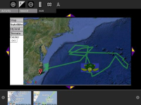
Turtle GPS in Map Activity
My main technical goals were to improve speed and add collaboration. Google's Static Maps and a few JavaScript methods can make an interactive map (clickable markers, double-clicking to zoom) even with low bandwidth.
A Jabber connection, which I tested with the Traveling XO, lets classes share a map and edit each other's markers. There are also options for classes to store or share their markers online.
Each marker can have an embedded photo, Google search, or Wikipedia article. The code wiki::Dragonfly embeds a Wikipedia article in Simple English, and wikiFR::Anisoptera embeds the article in French.
A maps library offers real-life maps used in shipping, environmental science, and medicine. The elephant and turtle-tracking maps have been the most popular.
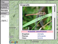
Embedded Wikipedia article
- The Map activity is ready to download from http://maptonomy.appspot.com/Map-3b.xo
- For more information, go to the SugarLabs page at http://wiki.sugarlabs.org/go/Activities/Map
- You can add to the maps library by posting a link to a map or KML file in a comment, or going to http://maptonomy.appspot.com/mapmaker.html
I would greatly appreciate your feedback
Nick Doiron is a Civil Engineering major at Carnegie Mellon University. He is also Curriculum Designer for the Boston-area nonprofit Hello Laptop, Hello World

I think you can better base your activity on the Free OpenStreetmap.
http://www.openstreetmap.org/
It is not as comprehensive as Google Maps, but it might fit your bill and is Free Software.
Google Maps is proprietary. They will let individuals use it for free. But for any organized use of Google Maps you need a license.
If your activity becomes popular, Google will notice the "clicks". Then they might or might not allow this use.
Google very well might support this OLPC use. But the question is whether you want to depend on that goodwill?
Winter
Btw,
I forgot to tell you how great this is. I think that the ability to read maps would be a great education for children.
Half of social geography is about knowing where people live. The other half is knowing why they live there. Or maps and history. You just supplied the one half.
;-)
Winter
Speaking of maps, here's one from OLPC Australia (on Google Maps) showing their project locations:
OLPC Australia Google Map
Those XO guys seem to be kinda large though. Like Godzilla XO's stoping around Down Under.
Winter, I've checked Google's license and there is a limit of 1000 unique map requests per day *on the end user*. If XOs are sharing a view, they make identical requests, possibly getting data from the school server cache. Only once after hours of testing did I hit 1000.
OpenStreetMap is a great project, but detailed global satellite and aerial maps, especially where roadmaps are lacking, are a strong point for XOs using Google Maps.
I knew the Google Maps API only from commercial use. I have reread the licenses (I tend to suppress this kind of memories).
It looks indeed that you are right and an OLPC initiative would work fine.
I am a little afraid schools might run into the 1000/day limits faster than you might think. Cashing can even throw off the daily limit algorithm.
Another thing is that Google's license explicitly prohibits the use in countries banned by the US. I am not sure which countries these are, but I do not remember any OLPC target countries in this list.
Still, you might want to have a look at the OpenStreetmap project. For one thing, they might be very helpful :-). On the other hand their coverage of the developing world will probably be "sparse", but that will improve over time. Given that they would need a GPS tracker, the children will not be able to contribute (which would have been an even better educational project).
I expect aerial photography will be a bandwidth hog, so missing that might end up being a feature ;-)
Keep up the good work!
Winter
Hi Nick,
This looks great! Where do you want me to post bug reports?
If you edit http://wiki.laptop.org/go/Talk:Map_%28activity%29/v3page or post at the SugarLabs page, I'll see it.
Thanks for having feedback =)